If you are going to read this blog, be warned! This is the longest walk I’ve done so far and this means that this blog has to reflect that. Refreshments will be provided when we reach our destination and before we return home.
When I was younger and fit I enjoyed walking, especially in the hills around. Every spring I would start my season with a walk along the coastal path from Penarth to Sully. I would have lunch at the Captain’s Wife in Sully and return to Penarth having enjoyed a lovely day out.
I suppose it was the foot and mouth outbreak which stopped this routine when the footpath was closed, and since then a number of other events have restricted my walking ability, not least of which was having three knee replacements. (Yes, three, like the Isle of Man!) For those of you wondering what I have done with the third knee replacement, it’s a sort of spare wheel in case one of the others gets a puncture. (Well ask a silly question...)
When I received my “Move More” pack from Macmillan, I had to set goals and one of the difficulties was knowing at that stage what I would be able to achieve. I could make grand gestures – climb Everest or swim the channel – but I wanted to set more realistic goals and I had wondered about repeating that walk, but at my then level of fitness didn’t really dream it would be either possible or wise! Indeed my doctor thought I should stick to strolling along the canal bank and feed the ducks! Oh Yeah?
Another secret goal, please don’t tell anyone, is to learn to swim – it won’t be quite so much like a dolphin, but more a hump backed whale. But water is so wet and I’ve shelved that one until someone invents dry water.
Well back to my other goal, I was already walking 5 or 6 miles and thought this walk which I estimated to be about 8 miles might be possible. So since my camellia was in full bloom (and looking really glorious – I’m sure the neighbours think I must be a marvellous gardener!) and I wasn’t going to do any gardening until the flowers had died the walk was on.
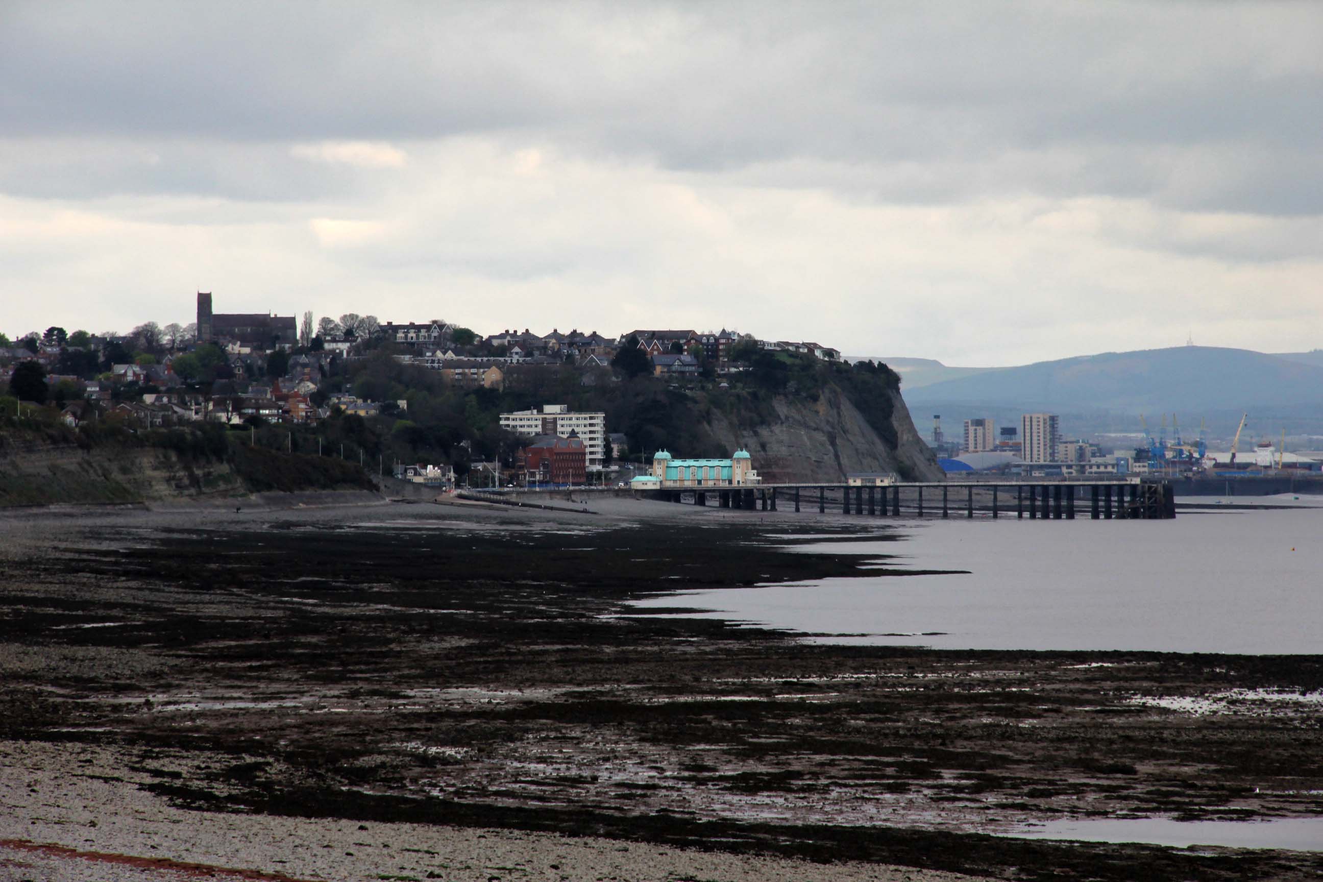
Penarth is a lovely Victorian town on the banks of the Severn estuary. The funnel shape of the estuary makes the tidal range here the second highest in the world, only the Bay of Fundy in Canada being higher. At low tide large areas of the rocky beach are exposed with some wonderful patterns in the rocks exposed. There is a lovely Victorian Pier which fans of Gavin and Stacey would have seen in some of the episodes, and in summer there are pleasure cruises from the Pier aboard the paddle steamer Waverley. To the west of the seafront the cliffs rise steeply and there is a lovely cliff top walk, a favourite with dog walkers and grandparents with their grandchildren.
The view across the water is to the north Somerset coast, but dominating the view are the two islands, Flatholm and Steepholm, about 6 miles or so from Penarth. Steepholm is uninhabited and is a bird sanctuary whereas Flatholm has a lighthouse, farm and the most southerly pub in Wales!
I parked the car in the cliff top car park opposite Cioni’s Bistro and with camera in hand and picnic in my bag I set off along the cliff top walk looking for an opportunity to photograph Flatholm and Steepholm. After several attempts I gave up and continued my walk. Along the Cliff top are a number of large houses with good views over the estuary. The estuary is a busy shipping channel for the ports of Cardiff, Newport and Avonmouth, as well as a marvellous area for leisure sailing. The tide is low and no commercial shipping can be seen, but loads of small craft, both sailing boats and motor boats.
At the end of the cliff top walk is a gate leading to the path proper. As I remember the path it used to be wet and muddy, but it is now a gravel path which is well drained and a pleasure to walk along. The first thing that strikes me is the bird song and this is to accompany me for most of the walk, but visually it is a stunning sight. The blackthorn bushes are a blaze of white flowers. The undergrowth blocks the view of the estuary for most of the path, just giving tantalising glimpses. Occasionally, there is a small well worn path to the edge where there is a viewpoint, not an organised one, but just access to the edge of the cliff. I explored one of these to find someone standing very close to the edge but I stood further back with my back firmly pressed against a tree to take a picture. There is quite a steep drop to the rocky surface below and I have no head for heights!
As the path approached Lavernock Point, there was a small path leading down to the beach and from here there was a lovely view back towards Penarth. A young family were settled on the beach having a picnic. I retraced my steps and continued on my journey. On the cliff top was the Marconi Tower, a small square building which was all boarded up. A small VHF aerial had its lead disconnected and I assumed the building was no longer being used.
The coast path finishes here and a gate gives access to Fort Road. At the start of Fort Road there is a small church on the right which has a plaque on the wall commemorating the fact that Marconi had carried out his early experiments at Lavernock point to demonstrate that his spark transmitter could send messages over water. He carried out two trials, the first as far as Flatholm Island, and the second over the longer distance to Brean Down in Somerset.
On the left hand side is the Lavernock Point Holiday Park which is quite a large collection of chalets.
The road twists and turns as it rises slowly towards Lavernock Road between Penarth and Barry. There are a few large houses and also some woodland where I noticed some clumps of primroses in flower, and a lone clump of bluebells.
As I reach the end of the road my knees are starting to complain and I wonder whether to return or carry on. I decide to carry on, since I can rest when I reach Sully and my knees should recover, and if they don’t, I can hobble back to the road and catch a bus into Penarth.
A short walk along Lavernock Road and then I take St Mary’s Well Road which snakes its way down to the coast. The road is slightly wider than Fort Road and there is a footpath in places. I meet a woman with garden shears in hand cutting a branch from a blackthorn bush at the side of the road. She looks guilty and very embarrassed and so I say “Caught red-handed!” She explains that she was looking for a decorative branch to hang eggs on for her grandchildren. She thought the bush was hawthorn, but the leaves were ovoid so it is more likely to be blackthorn.
Further down the road there was a wartime watchtower which was for sale the last time I came here. It has now been very tastefully converted into a house with a lovely view from the top floor. I noticed the large number of dandelions and celandines in the verges as I stumble into Sully Island and make straight for the Captain’s Wife – the pub that is, not the person.
Phew! If you are still with me on this walk, now is the time to pour yourself a drink before we continue.
After a beer and a read of a discarded newspaper, I venture out to sit at a picnic table looking out to Sully Island to eat my rolls. That was a mistake! I should have eaten my rolls first and then gone for a beer. Whilst I was in the pub, a fine cold drizzly rain had started.
The tide was very low and the island was not an island at all, for all the land between the island and the shore was dry. Normally, the island is reached via a causeway at the start of which is a warning that the sea is dangerous and people should look out for the tide which rises quite quickly. People have been drowned here! On one occasion I visited the island with my nephew when the tide was over a foot below the causeway and by the time we had reached the island the sea was lapping at its lowest point. We returned to the mainland immediately and were paddling in a foot of water by the time we reached the shore.
On my journey I noticed how people very generously helped nature to make the place more interesting. The route was decorated with a discarded blue Thomas the tank engine, a toilet cistern and toilet seat, the latter would have made a useful roadside feature to welcome the weary traveller, if you had left the toilet as well. An empty one litre plastic ice cream carton would be a useful holder for all those odd screws left over when men repair things and some broken fencing would be good for the wood burner. I would like to thank those responsible for the interesting assortment of objects placed for me to find, unfortunately it was too far to carry them back to my car.
As the rain was getting more persistent I started back almost straight away. When I reached the main road, I wondered whether to get the bus back to Penarth, but the rain was easing, and I could see no times for the buses so I trudged on. All the while my knees were complaining, and people were giving me strange looks as I kept on muttering “Shut up knees”!
At the start of the coastal path I met three men (not in a boat, but they did have a dog). They were putting the world to rights as only we of the experienced years can do. They introduced themselves as the last of the summer wine, but I couldn’t see Compo there.
Along the path, the birds were singing from the tops of the trees, lots of robins, a chaffinch and a blackbird. They serenaded me all the way back to Penarth.
As I sat in Cioni’s Bistro drinking my coffee and eating a well earned cherry bakewell, ( don’t tell my DN) I checked my pedometer. I had underestimated the distance as I had walked 10 miles there and back. Reflecting on this, when I started “Move More” last September, I was limited to walking only 3 miles before I was out of puff and my knees complained.
Perhaps Everest is possible after all!?


